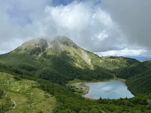
Mt Aizu-Komagatake (会津駒ヶ岳, aizu-komagatake) is a Hundred Famous Mountain located in Fukushima, about a 4 hour drive from Tokyo. Its most iconic view is from the lake near its summit, which has a beautiful reflection of the mountain’s peak. It’s also accessible via an overnight train, which provides a unique experience for public transport users.
Since I wanted to actually get some sleep, I decided to hike it as a day trip with a couple of friends. The course time is about 6 hours, so it was a bit of a tight schedule, but we pulled it off! We set out from Tokyo at around 6am, and thankfully there was zero traffic on our drive, so we arrived at the trailhead at around 10am.

The trail has 1150m of elevation gain over 10km, so it was a bit steep, but I find that when you hike together with a group, you tend to go at a steady but more relaxed pace, so I didn’t find the climb to be that bad. (Also, you get to take your mind off of things by chatting to your friends!)


The trail starts off amongst the trees. We hiked right at the end of October, so we were just in time to see some stunning autumn leaves from mid-way up the hike.


After about 90 minutes, we made it out of the tree line, and we could get our first glimpse of the mountain’s ridge.


And finally, the peak of Mt Aizu-Komagatake comes into view! The mountain was such a beautiful green. From here the trail also switches to a boardwalk, which was a welcome sight after a 2 hour climb.


Apparently a phrase that has been trending among Japanese hikers recently is “kusa momiji” (草紅葉 or literally “grass autumn leaves”). Really, it’s just the grass turning brown, so we joked that the grass must be happy that it’s getting such attention. However I really enjoyed its contrast with the surrounding greenery.

The Komanokoya mountain hut (駒の小屋) is quite close to the summit, so as this came into view it also boosted our morale.

Also as you approach the hut, you can get a clear view on the left of Mt Hiuchigatake. Hiuchi, Mt Shibutsu and Mt Aizu-Komagatake are all apart of the same Oze National Park, but when people refer to “Oze” they generally mean Hiuchi and Shibutsu, so Aizu-Komagatake is kind of like the forgotten third sibling.

Just before 1pm we reached the mountain hut. There were a couple of groups of hikers here who were taking a break before making their descent back down. Apparently today (the last weekend of October) was also the final day of operations for the hut.

We were honestly blessed with perfect weather, and so it’s from the hut that I got one of my favourite shots of the entire hike. Mt Aizu-Komagatake’s peak is perfectly reflected in the lake.

I’m not sure what the actual official name is of this lake, since I saw about three referenced in different places - Koma-no-ike (駒の池), Koma-o-ike (駒大池) and Koma-no-o-ike (駒ノ大池). We left our bags here, since the summit is only a 10 minute walk away.


From the summit, if you have a spare 2 hours, you can continue along the trail towards the Chhumon-ike lake (中門池, chuumon-ike). We decided to skip that this time, but even just looking out towards that trail was gorgeous.

As we headed back towards the hut, we got to take in the views out towards Mt Hiuchigatake again.


By the time we got back to the hut it was 1:30pm, so we had a quick lunch before beginning our descent. When we first arrived, there weren’t any other hikers around, so we were a bit surpised thinking that everyone had already descended, but as we ate, some other hikers trickled in, probably returning from the hike out to the Chumon-ike.
From here, the descent was back down the same trail, and we finished at about 4pm, right on schedule and before it got dark.


Hiking course details
| Date climbed | Length | Course time |
|---|---|---|
| 2024-10-27 | 12km | 7h15min (the expected time for an average hiker without breaks) |
The standard day trip course for Mt Aizu-Komagatake starts at the Takizawa trailhead (滝沢登山口). From here it’s a 12km out-and-back course, passing by the Katanokoya mountain hut, the peak of Mt Aizu-Komagatake and finally the Chumon-ike lake, before taking the same trail back to the trailhead.
Due to time constraints, we shortened the course by 2km and 1.5 hours by skipping Chumon-ike.
If you are coming via public transport, the walk from the bus stop to the trailhead is an additional 30 minute uphill walk one way.
There are toilets available at the trailhead’s bus stop and at the mountain hut near the summit.
Public transportation access
Mt Aizu-Komagatake is accessible with public transport, via an overnight train that leaves from Asakusa station (浅草駅) at 23:45. It arrives at Aizukogen-Oze-Guchi station (会津高原尾瀬口駅) at 3:08am. The train only runs on Friday and Saturday nights, from June through to mid-October and you’ll need to book your tickets in advance (see the 2024 info here).
From there, the bus to the trailhead departs at 5:00, arriving at the Mt Aizu-Komagatake trailhead bus stop (会津駒ヶ岳登山口バス停) at 6:00. There is quite a gap between the train and the bus, but apparently you are allowed to wait inside the train until the bus arrives.
Car access details
| Car park | Time (from Tokyo) | Round trip cost |
|---|---|---|
| Takizawatozanguchi Parking Lot (滝沢登山口駐車場) | 4h | ~12200 yen |
The main car park for Mt Aizu-Komagatake is quite small and probably fits only 10 - 20 cars. However along the road up to the trailhead, there are multiple other smaller carparks where you can park your car. Some cars also end up parked along the side of the road.

Depending how early you get there will depend how far you have to walk to get to the trailhead. We arrived around 10am, but got lucky and grabbed a spot from someone who had already finished their hike for the day, and so only had about a 10 minute walk to the trailhead.

Also note that there is no toilet at the trailhead itself - the nearest one is at the bus stop on the main road. I would recommend stopping at the nearby Michi-no-eki Oze Hinoemata though, as the toilets are probably much cleaner than the bus stop ones. There is also no reception at the trailhead.


Leave a comment