If you’re going to be climbing mountains in Japan and are looking for a GPS hiking app, I highly recommend YAMAP. It’s the most popular app for hikers in Japan, and you are guaranteed to find recent activity diaries and routes for even the smallest of local mountains.
Unfortunately YAMAP can be a little hard to navigate if you’re not fluent in Japanese, since it only has partial English translations. But I think with any UI, once you get used to where all of the buttons are it gets easier to use so I hope this guide can help you out.
⛰️ If you have any other YAMAP questions, feel free to leave a comment at the bottom of this page, or reach out on Instagram! You can also check out my hiking in Japan page to see my latest hikes.
This guide covers how to use YAMAP’s website to check the latest trail conditions, as well as how to use the GPS app on your phone while out on a hike.
Navigating the YAMAP website
Even if you don’t plan on using the app while out on the trail, YAMAP is super useful to see the available hiking courses or double-check the latest trail conditions. Even for a super niche mountain (and I’ve climbed quite a few), I can bet you that there will have been at least one activity log uploaded within the past week.
And if there aren’t any, this should probably set some alarm bells ringing - maybe there are road closures on the way to the trailhead making it inaccessible, or the trail itself may be closed off (which occasionally happens with volcanic mountains in Japan).
Since I don’t hike in the snow, I can also use it to double-check in the colder months to make sure that the trail is still snow-free by looking at user photos.
The easiest way to search for a mountain and its courses is to go to YAMAP’s mountain search page:
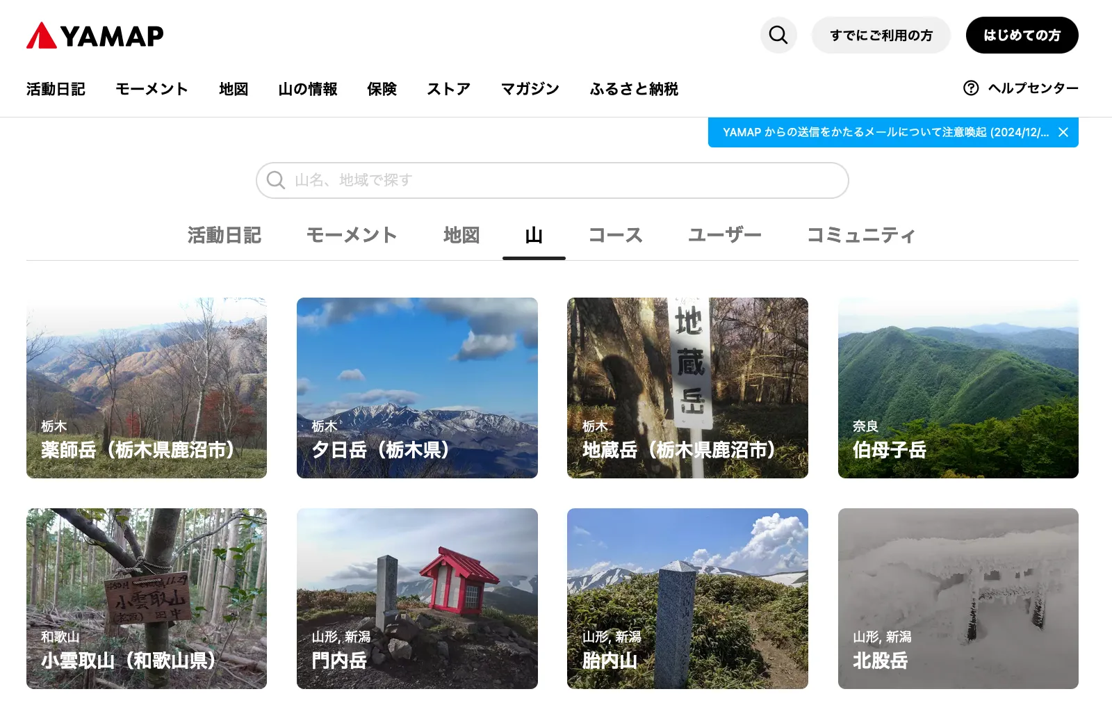
The first thing you’ll need is the Japanese name of the mountain you’re interested in. For example, if you wanted to hike Mt Tono-dake (or Mt To), you could find its Wikipedia page which handily has its name in Japanese - 塔ノ岳. If you input this into the search box for the mountain, you should be able to find your mountain.
💡 Sometimes mountains have similar or same names in Japan - an easy way to double-check the mountain is the correct one is by looking at its elevation.
YAMAP’s score range
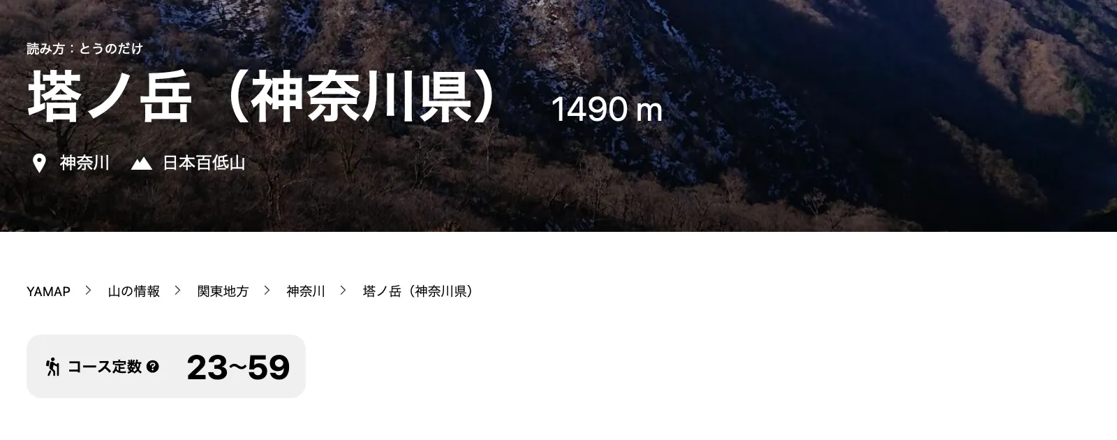
Once you end up on your mountain’s details page, one of the first things you’ll see underneath its name is a course score range (コース定数). Japan doesn’t have a proper course difficulty rating system like other countries do, but this number lets you get a sense of how physically exerting the mountain will be. It’s calculated with a formula using metrics like the elevation gain and distance.
Since a mountain usually can be hiked from different trailheads and/or has course variations, the score is a range. If you’re interested in doing a quick day hike, you’ll be looking for the bottom number to be around 10. A score of around 30 is on the top-end of a day hike (expect 8 hours) and beyond that you are looking at multi-day hikes.
The model courses section
If you scroll down a bit down the mountain’s profile page, you’ll come to the model courses (モデルコース) section. Honestly I take it for granted, but YAMAP has done a great job of mapping out so many course options for each mountain.
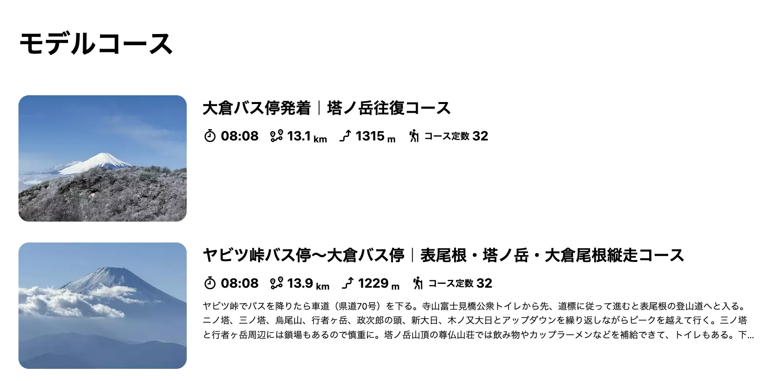
From a quick glance you should be able to get the expected course time, distance, elevation gain and difficulty score of each course to help you narrow down which one you might be interested in. The name of the course lists out the trailhead it starts at, as well as the type of the course:
- 往復 means out-and-back: you walk to the peak and then take the same trail back down
- 縦走 means point-to-point: you’ll start at one trailhead and end at another
- 周回 means loop: you’ll start and end at the same trailhead, but take a loop course
If you didn’t already have a specific course in mind, you may need to do a bit of your own research to figure out which one you are interested in - taking into account things like public transport access or car parking options. If you check out my hiking in Japan page I have done some of this legwork for quite a few mountains to make things easier for you!
Looking at other user’s activity logs
With so many YAMAP users, there are a lot of activity logs uploaded each day to the app. From the mountain’s profile page, you can scroll down to the related activity logs (関連する活動日記) section.
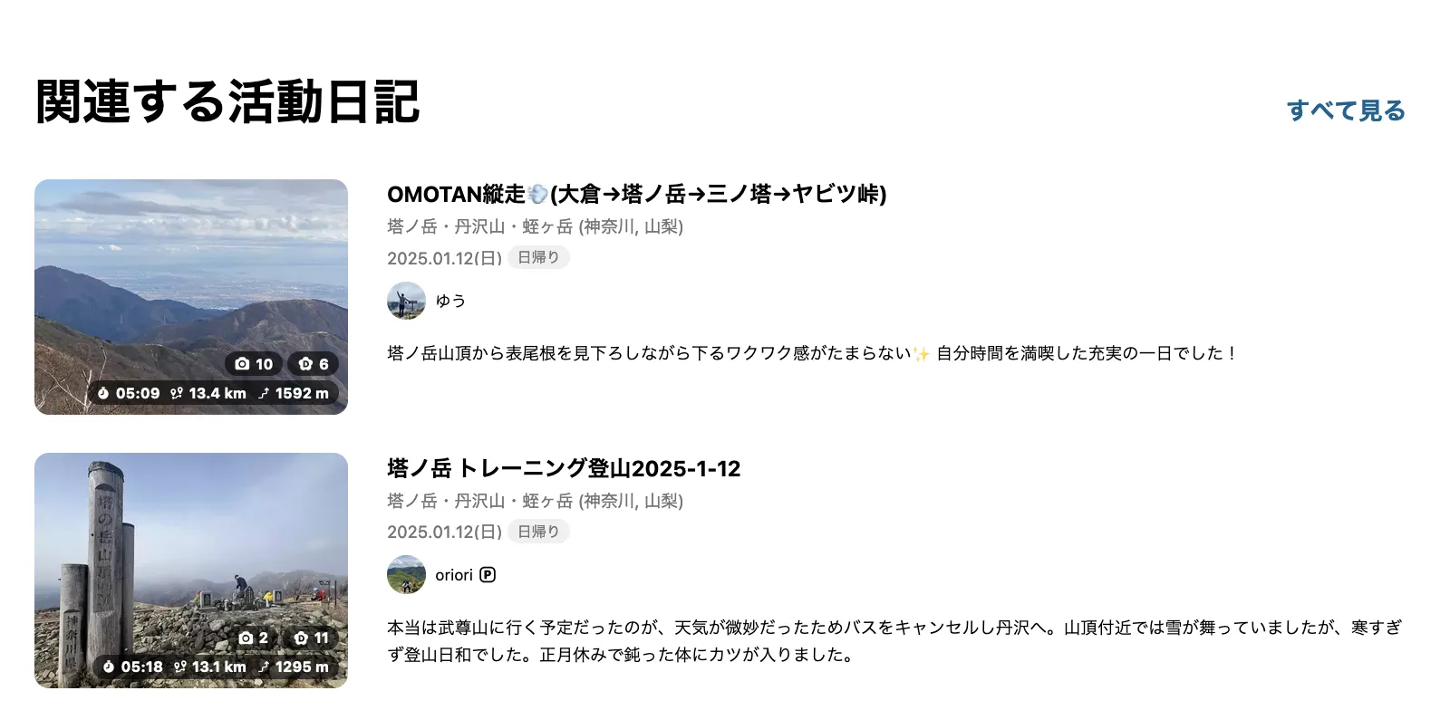
You can click into one of these, or if you click the すべて見る or “show all” button in the top right, you’ll be able to taken to a new page which shows you a list of all the activity logs.
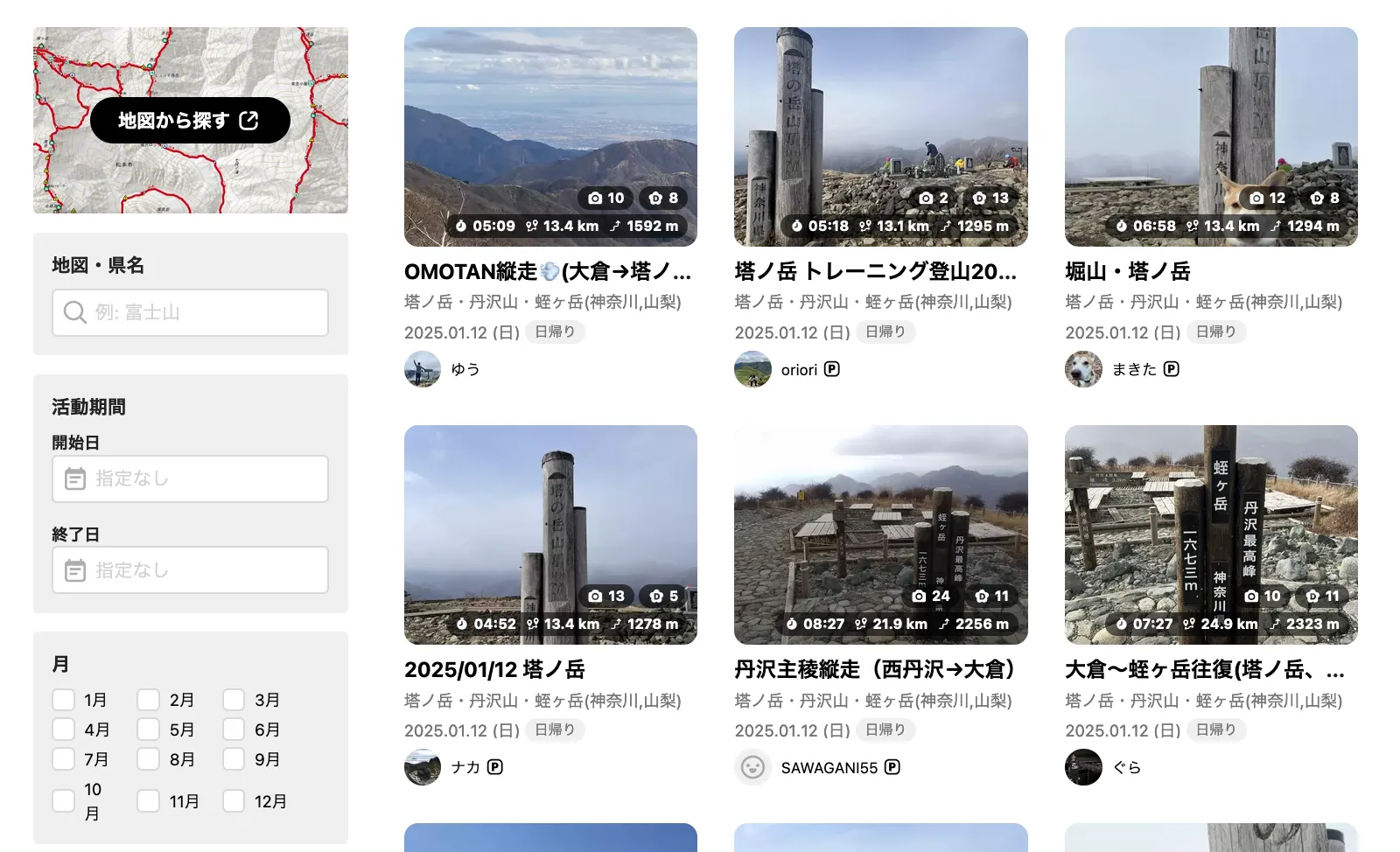
The activity logs page does have some limited filter options - you can filter by date using the 活動期間 inputs on the left hand side, or by month using the 月 checkboxes below that. This is useful if you’re planning a hike for later in the year and wanted to see what the trail conditions looked like at that time last year.
From here, you can start clicking into people’s individual activity logs to see their photos, the course they took, and so on. Some people are quite diligent in writing long activity descriptions, in which case you can use a translation app like DeepL to see what they’re writing about.
💡 YAMAP does work at first without being logged in, but after a couple of views of activity logs, you may be prompted to create an account to keep reading.
Using YAMAP’s mobile app
So if you are interested in using YAMAP while out on the trail, you’ll need to download their mobile app. This lets you download maps so you can hike while offline.
🔗 YAMAP has a friend referral system, so you can use this link to download the app on your mobile, if you don’t mind it adding me as your friend. If you’d prefer to stay anonymous, you can look for the YAMAP app in the Google Play or Apple App stores.
In the next sections I’ll run you through how to access model courses and so on for YAMAP’s mobile app.
Finding a model course on the mobile app
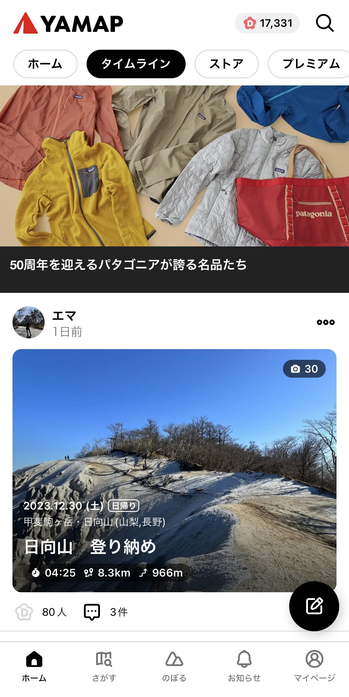
When you first open the app, you’ll land on the home page. There’s an activity feed (if you follow other YAMAP users), an online store and other useful things like recommmended routes.
You’ll notice 5 menu items down the bottom:
- ホーム: Home page / activity feed
- さがす: Search for mountains
- のぼる: Your planned hiking routes
- お知らせ: Notifications
- マイページ: Your profile page
For the moment we’ll be assuming that you already have a mountain in mind that you want to climb. So first let’s click on the second menu button from the left (さがす) to search for a mountain.
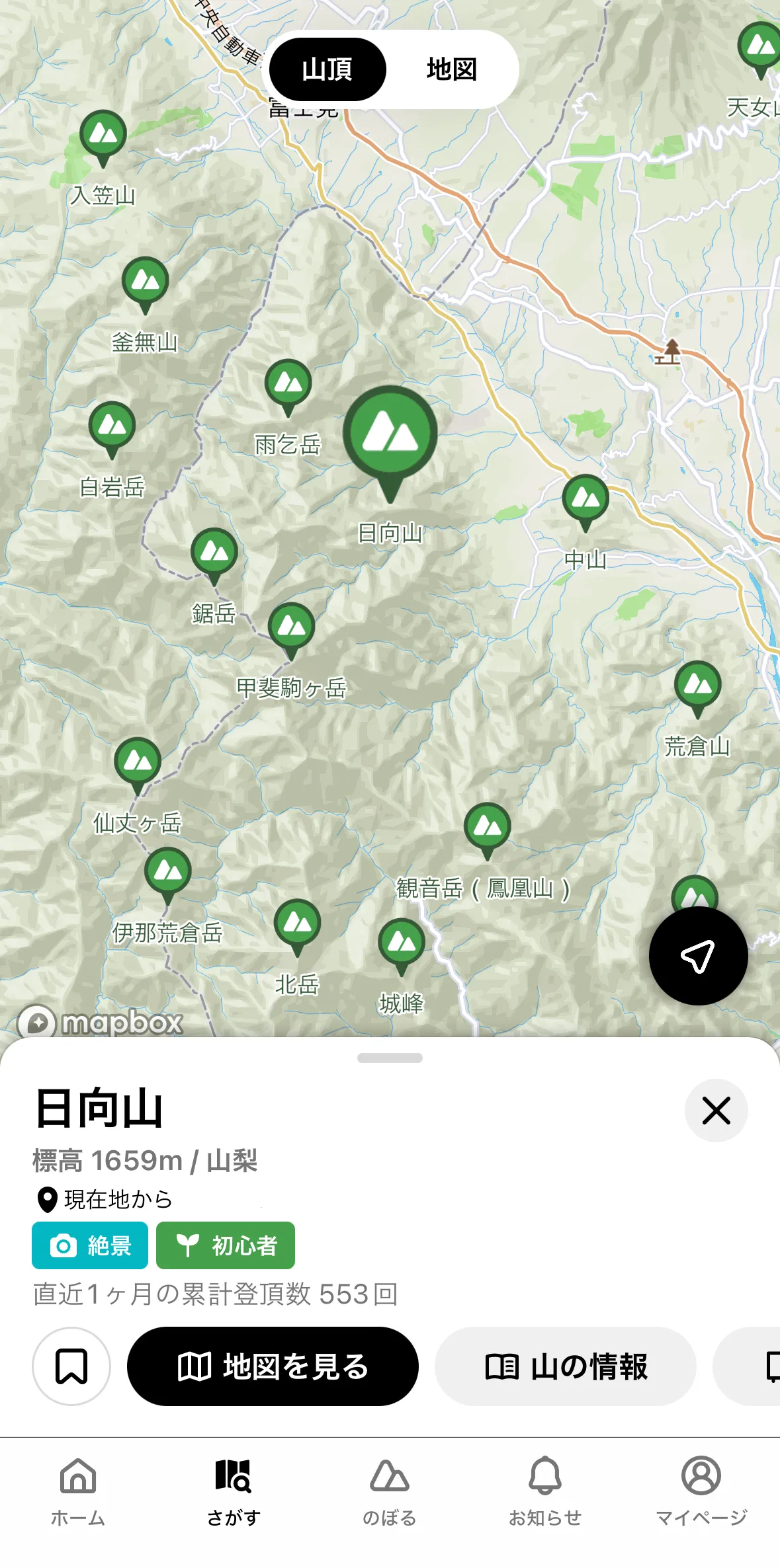
Once you type in the mountain you are looking for - this step seems to work in both English and Japanese - it will probably return a lot of results, since mountains aren’t that uniquely named in Japan. It’s useful if you know the elevation of the mountain or which prefecture it’s in, as this will help you narrow down your search.
Once you’ve picked the mountain, you’ll get to see the mountain on a map - if you know the general area of where the mountain is, this also helps you verify that you’ve found the right one!
From here, click the grey 山の情報 button on the bottom right, which will give you more detailed information about the mountain.
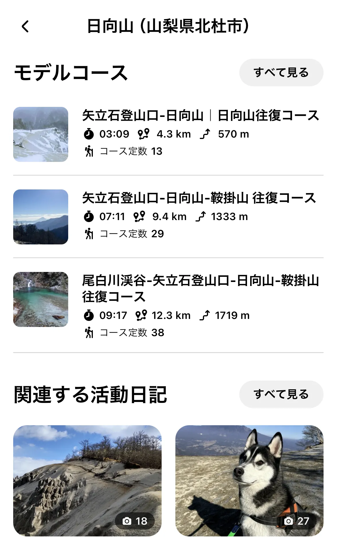
Now you will be on the details page for that mountain. There’s quite a lot of information to see here but the two things we will be interested in are:
- モデルコース: The list of model courses, created by YAMAP
- 関連する活動日記: The most recent activities logged by people who have climbed that mountain
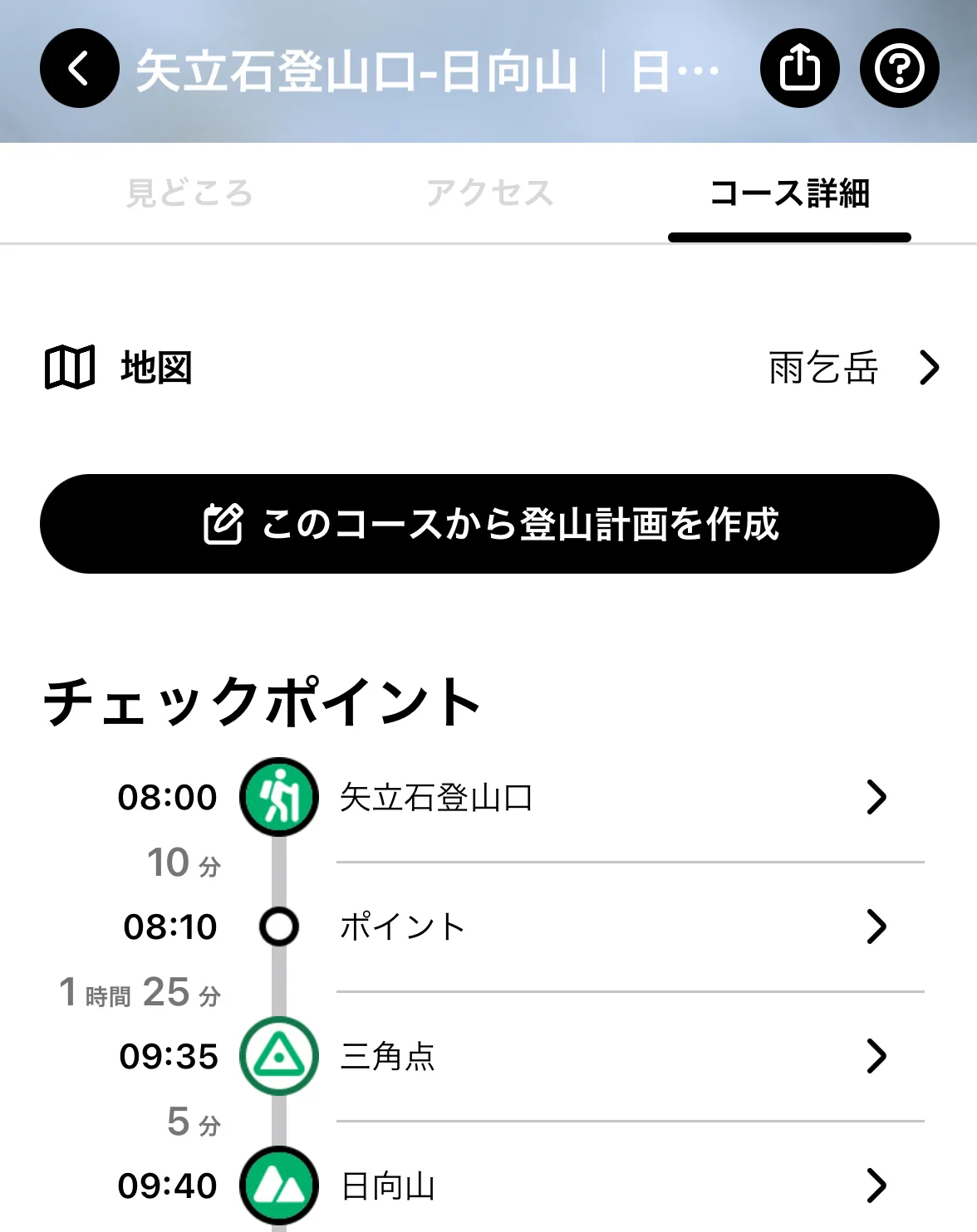
Let’s assume we want to create a hiking plan based on a model course.
Click on the one you want, and it will give you a example hiking plan with a time schedule of where you’ll hit what checkpoints.
To copy this course and create your own plan, click the big black button (このコースから登山計画を作成).
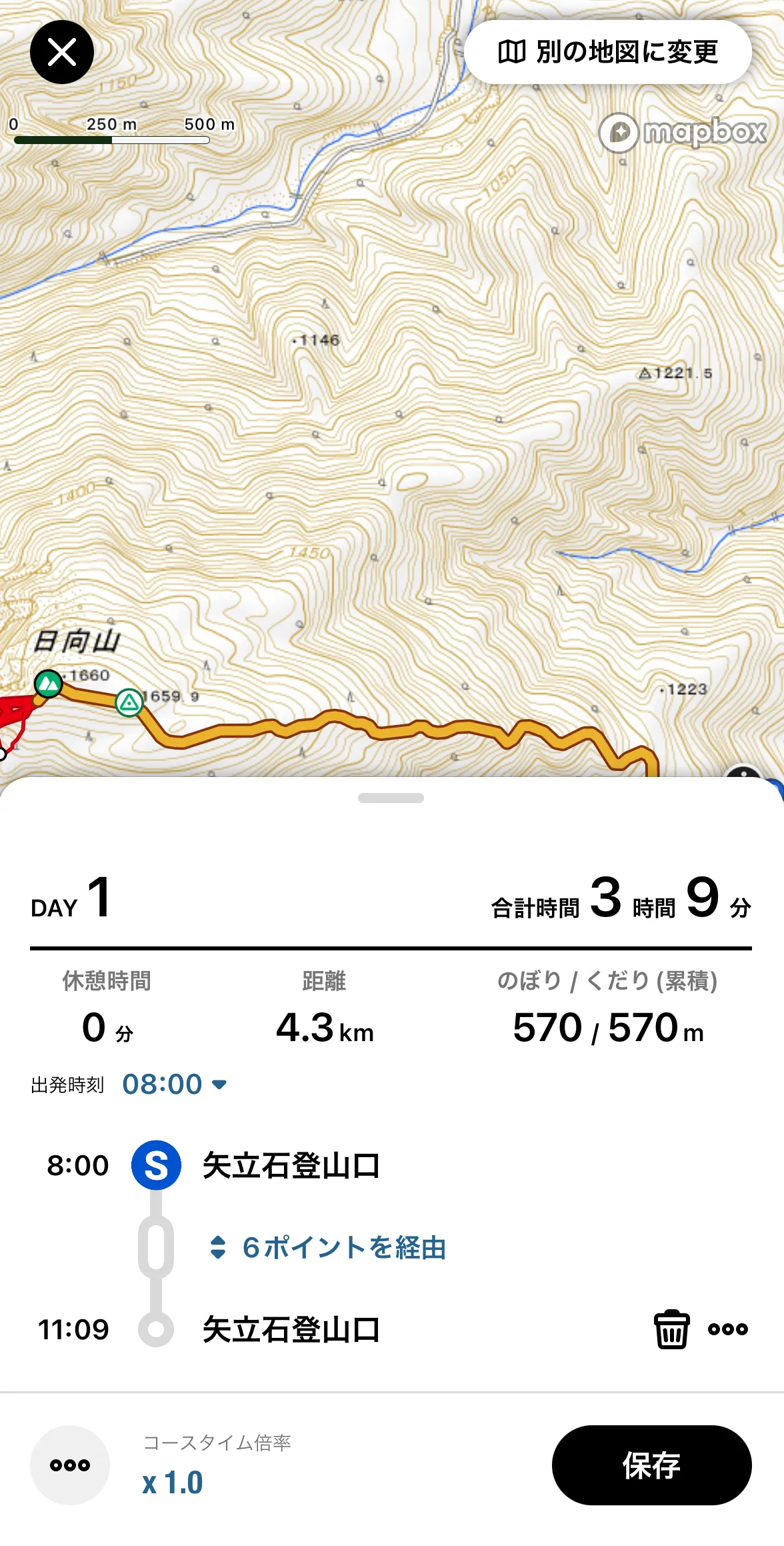
After you copy the model course, it will open a new draft plan with the map already open.
From this screen you can:
- See the course you’ll be taking. Your path is the bit that’s highlighted in yellow, and red is for alternative routes used by other courses.
- Change the hike start time (in the screenshot it’s set to 08:00am)
- In the bottom left there is a course time modifier to make your hiking plan longer or shorter e.g. If you have a 10 hour course and you set it to a modifier of 0.9x, the timing will be updated to finish in 9 hours.
Click the black save button (保存) in the bottom right once you’re done making changes to the map.
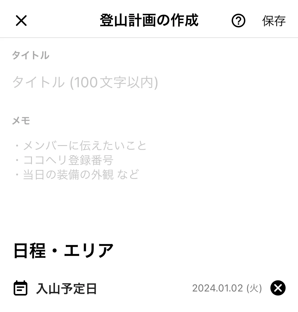
Once you’ve closed the map you can optionally fill in the title and memo fields, as well as a date field for when you will be doing your hike.
Once you’re done, click the save button (保存) in the top right.
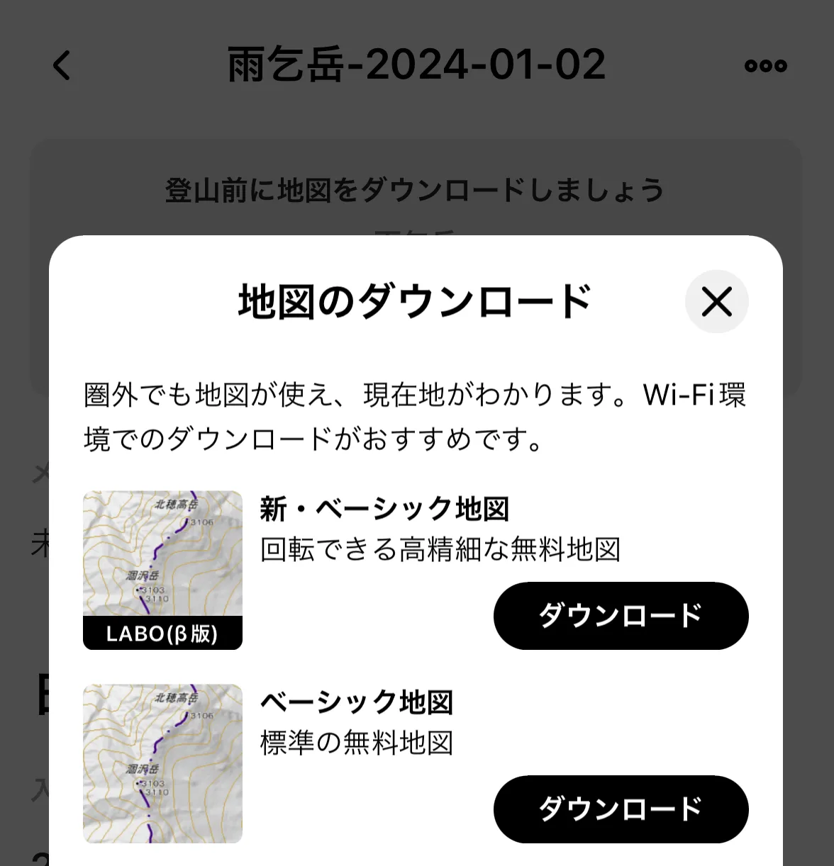
Now you’re done with your plan! You’ll see a big black black button to download the course map (地図をダウンロード). If you click that, you’ll see a list of map download options pictured in the screenshot.
I always just choose the top LABO one, because it lets you rotate the map (the other ones are in fixed position).
You will most likely not have cell reception on the mountains, so I highly recommend doing this step before you forget to.
Submitting insurance details and hiking plans
After you have created your hiking plan, the app will prompt you to submit your insurance information, hiking plan and personal and emergency contact information to YAMAP. This will get used if you happen to go missing while on the mountain - presumably YAMAP will forward your information onto the authorities. Since it requires a Japanese address, if are coming from overseas, you can put the hotel you will be staying at after your hike.
This step is optional, and you can use YAMAP without filling it out. However I always strongly recommend letting someone know which mountain you are climbing and the course you are taking, to make it easier for the authorities / search personnel to find you in case something goes wrong.
Going on your hike
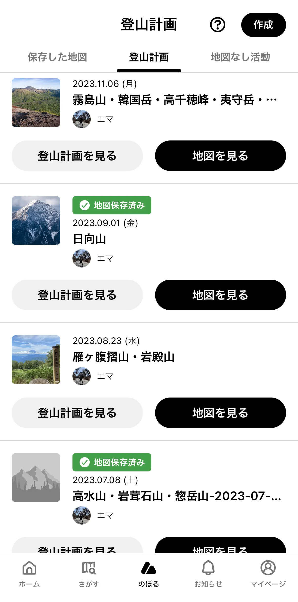
When it comes time for your hike, you can find all your hiking plans via the middle のぼる menu item at the bottom of the app.
The green lozenge next to your plan indicates that you have the map already downloaded for your route.
Click the black 地図を見る button to view the map for your plan.
Sometimes if you have a tiny amount of cell reception, it can be slow to load since it attempts to use your phone’s data. In that case, I switch my phone to airplane mode, and then it will open the map quite quickly.
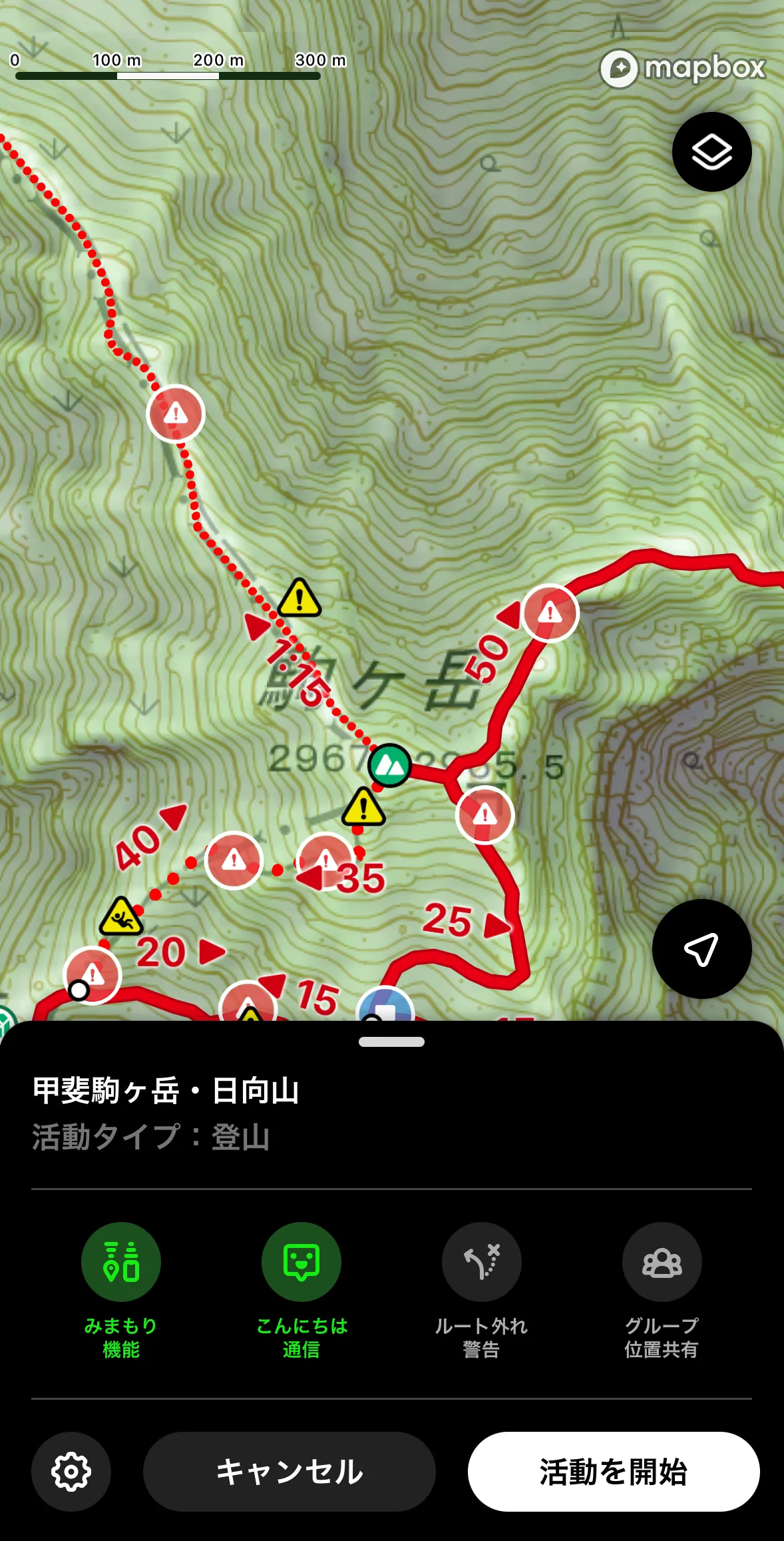
The map will show you useful information like danger spots (usually stuff like “be careful it’s steep here”), toilet locations, as well as notes left by other YAMAP users.
Click the white 活動を開始 button in the bottom right when you are ready to start your hike.
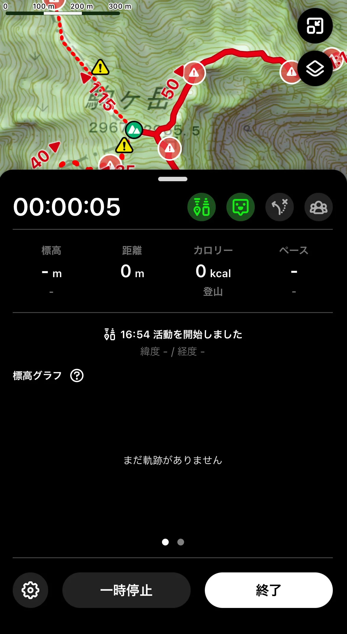
While hiking, you can pause the activity using the 一時停止 button on the bottom left. You don’t need to do this on a day hike as YAMAP automatically calculates your breaks for you, but it’s useful if you are doing an overnight hike - YAMAP will record longer pauses as an “overnight stay” in your activity diary.
When you’re finished with your hike, hit the white 終了 button in the bottom right.
Viewing your completed hike
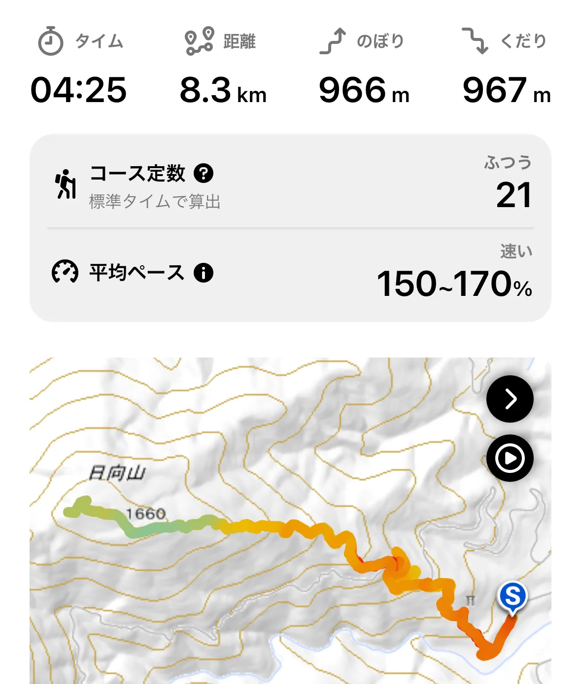
After your hike you can see the total time, distance, and elevation gain.
There’s also some additional stats around how much faster you were than the average course time, as well as YAMAP’s course score that I talked about earlier.
By default your activity diary will be set to private, and you have the option to edit it and add photos, etc. before making it public (only if you want to!)
Copying other users’s plans
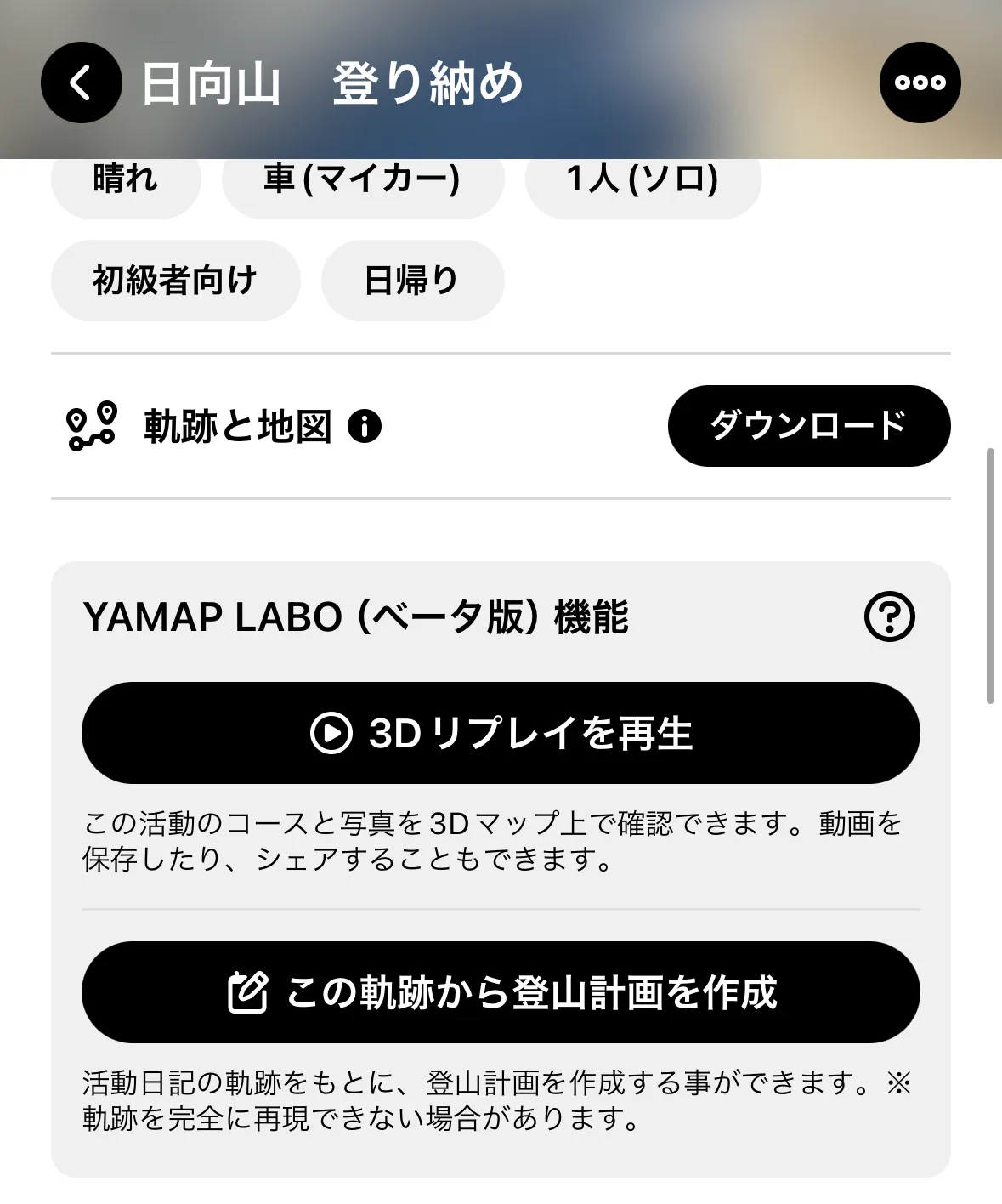
When viewing information about a mountain, you’ll remember there was a section to view other people who had recently completed a hike at the same mountain (関連する活動日記).
Sometimes the model courses don’t quite cover the route you want to take, so being able to copy other user’s activities is a feature I use quite a lot.
While viewing someone’s activity diary, you can copy and paste their plan with the black この軌跡から登山計画を作成 button.
YAMAP’s Premium tier: is it worth it?
YAMAP does provide a free 1-month trial of its premium feature, so if you are only in Japan for a short visit, I would recommend trying it out. Otherwise, the key selling point of its premium tier is unlimited map downloads. For free users, you can only download 2 maps per month.
So if you are in Japan for a long time, or live here, and want to hike more than twice a month, I would recommend the premium tier. It’s also a good way to support the developers - this is such a useful app to me, that I would pay the subscription fee even if I only hiked once a month.
Some of its other premium-only features include:
- Notifications if you go off the course trail while hiking
- Automatically notify LINE users of your location as you hike, which is useful if you want to keep your loved ones in the loop
- Uploading more than 10 photos to your activity log
Using YAMAP’s footsteps feature
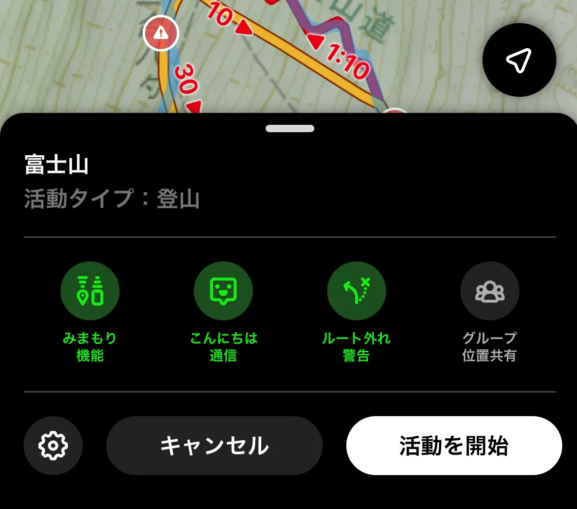
As an example of one of YAMAP’s premium features, YAMAP provides the option to overlay the exact path another user has followed on your map. To access this, you’ll need to download their footsteps or “trace” via the 軌跡と地図 section on their activity log.
Then when you open a map, click the settings cog in the bottom left.
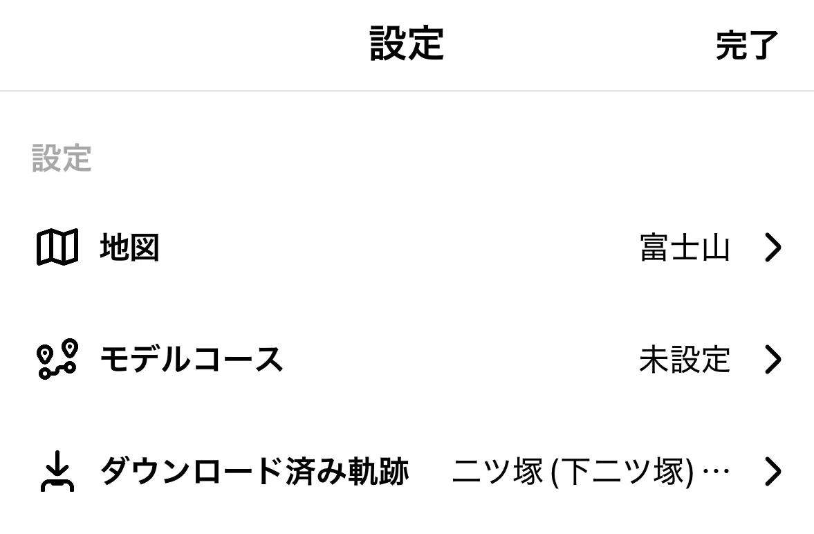
From the map’s settings page, you can set which trace to use with the ダウンロード済み option.
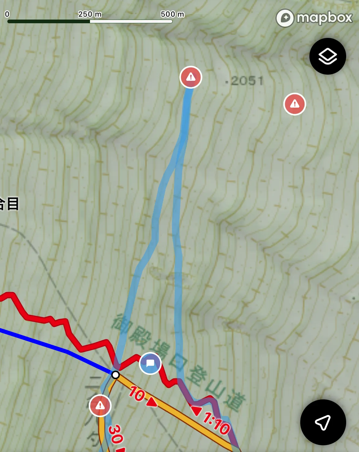
Once you have a trace selected, you’ll see it show up in a slightly see-through blue on the map.
This can come in handy if you wanted to follow someone else’s trail and they had diverged from the official course map.
Using YAMAP’s bookmark feature to save activity logs and model courses
If you find a model course you want to use on YAMAP’s website, you might notice the website has no option to create a hiking plan based off of this model course. You’ll have jump over to the mobile app to create one.
One way to “share” this information between the website and the mobile app is to use YAMAP’s bookmarks feature. When browsing on the web, there is a little bookmark icon in the bottom right of the page. Click that, and the activity log or model course will be saved as a bookmark.
If you then go to your mobile app and click the マイページ button in the bottom right, you’ll be taken to your user profile page. There is a ブックマーク option underneath your bio description. You can click this to access all of your bookmarks.
YAMAP vs AllTrails
AllTrails is another hiking app popular in English-speaking countries like America. If you are only coming to Japan for a short trip and are doing a one-off hike, then I think it’s best to stick with the UI are most familiar with. If you can find the hiking course you want to do on AllTrails, then that’s great! I recommend continuing to use it, although I would suggest to have a quick look at YAMAP to see the latest activity logs.
If you are planning on doing a lot of hiking in Japan, or Alltrails doesn’t have the hiking course you want, then I would definitely recommend switching to YAMAP. I’ve never used AllTrails so I can’t give a direct feature comparison, but YAMAP is very good in my opinion and wins even just in usage rates alone. As a rough comparison, we can compare hiking logs for Mt Tonodake:
- YAMAP had over 50 activity logs on a random Saturday in January
- AllTrails had only 5 activity logs between October and January
And this is for a super popular mountain! Once you start getting into smaller, local mountains, I can bet that the hiking logs start to become few and far between on AllTrails. And I think knowing the latest trail conditions is super important information to have as a hiker.
Other ways I use YAMAP
I’m a big YAMAP fan, and along with the stuff I mentioned above, the other things that I like about the app are:
- You can follow other users and bookmark their activity diaries if you find mountains that look interesting
- The app has a bit of gamification built-in with collectible badges depending on which mountains you climb
- There’s also a “people near you” feature which shows other YAMAP users you passed on your hike. More than once I’ve passed someone that I follow on YAMAP without realising it (one time, it was all the way up in Aomori!)
Although hiking can be a very solitary hobby at times, even when you hike alone the fact that you have a community of other hikers in your back pocket is kind of heart-warming so I’ve really enjoyed my time hiking in Japan, partly thanks to YAMAP. ♥️ I hope you can get some use out of it too.
👋 Thanks for reading! If you’re looking for more information on Japan’s mountains, check out my hiking in Japan home page. And if you have any other questions, please feel free to leave a comment below or send me a message on Instagram.


Comments
Leave a comment